The

route

Hydra might have no roads to speak of but its network of trails connecting its settlements with its beaches, monasteries, chapels, old pastures and its highest peaks are maintained in excellent condition What is Hydra’s Trail Marathon; The “Hydra’s Trail Marathon” is a 38 km mountain running event which aspires to highlight the beauty of Hydra’s mountain scenery. While the route is dominated by high mountain peaks with breath-taking sea views, there are also many portions where the athletes will be running along the coast, smelling the sea salt. Distance: 38,0 km Cumulative Elevation Gain: 2,000 m

Altitude Profile
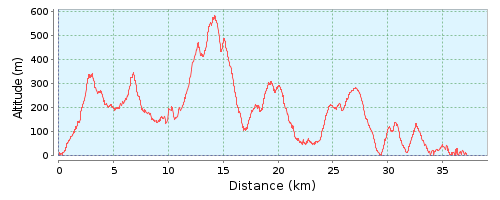
The “Hydra’s Trail Marathon” will start at the port and the first section, as well as the last is the same as that of the Rock Race.

0
groups
0
miles
0K
winners

People

say

Μπράβο σας συγχαρητήρια ,σας ευχαριστώ θερμά για την απίστευτη εμπειρία που μου χαρίσατε!
Στεφανής Σταύρος

Στεφανής Σταύρος

Ydra’s trail race 2017. Οι αλλαγές στη φετινή διαδρομή έφεραν την απόλυτη ισορροπία ώστε να μην έχει κανένας παράπονο αφού έχουμε πλέον πολύ γρήγορα κομμάτια αλλά και πολύ τεχνικά τα οποία απαιτούν πολύ προσοχή όταν προσπαθείς να κινηθείς γρήγορα! Για την διοργάνωση, την φιλοξενία και την ατμόσφαιρα δεν έχουμε να προσθέσουμε τίποτα αφού κάθε χρόνος που περνάει το άψογο γίνεται τέλειο και δε ξέρω τι άλλο θα μπορούσε να προσφέρει η εκδήλωση στο μέλλον.
Συγχαρητήρια σε όλους τους συντελεστές της επιτυχίας για ακόμη μια φορά!
Salomon Hellas

Salomon Hellas

Ύδρα Αγώνες Βουνού 2016… Δυστυχώς δεν μπόρεσα να βρίσκομαι εκεί φέτος για προσωπικούς λόγους… Εύχομαι όλα να πάνε καλά το 2018 και να είμαστε όλοι εκεί σε έναν από τους καλύτερους αγώνες που πραγματοποιούνται στην Ελλάδα!!!
Φωτιάδης Αλέξανδρος

Φωτιάδης Αλέξανδρος

Στεφανής ΣταύροςSalomon HellasΦωτιάδης Αλέξανδρος

Analysis

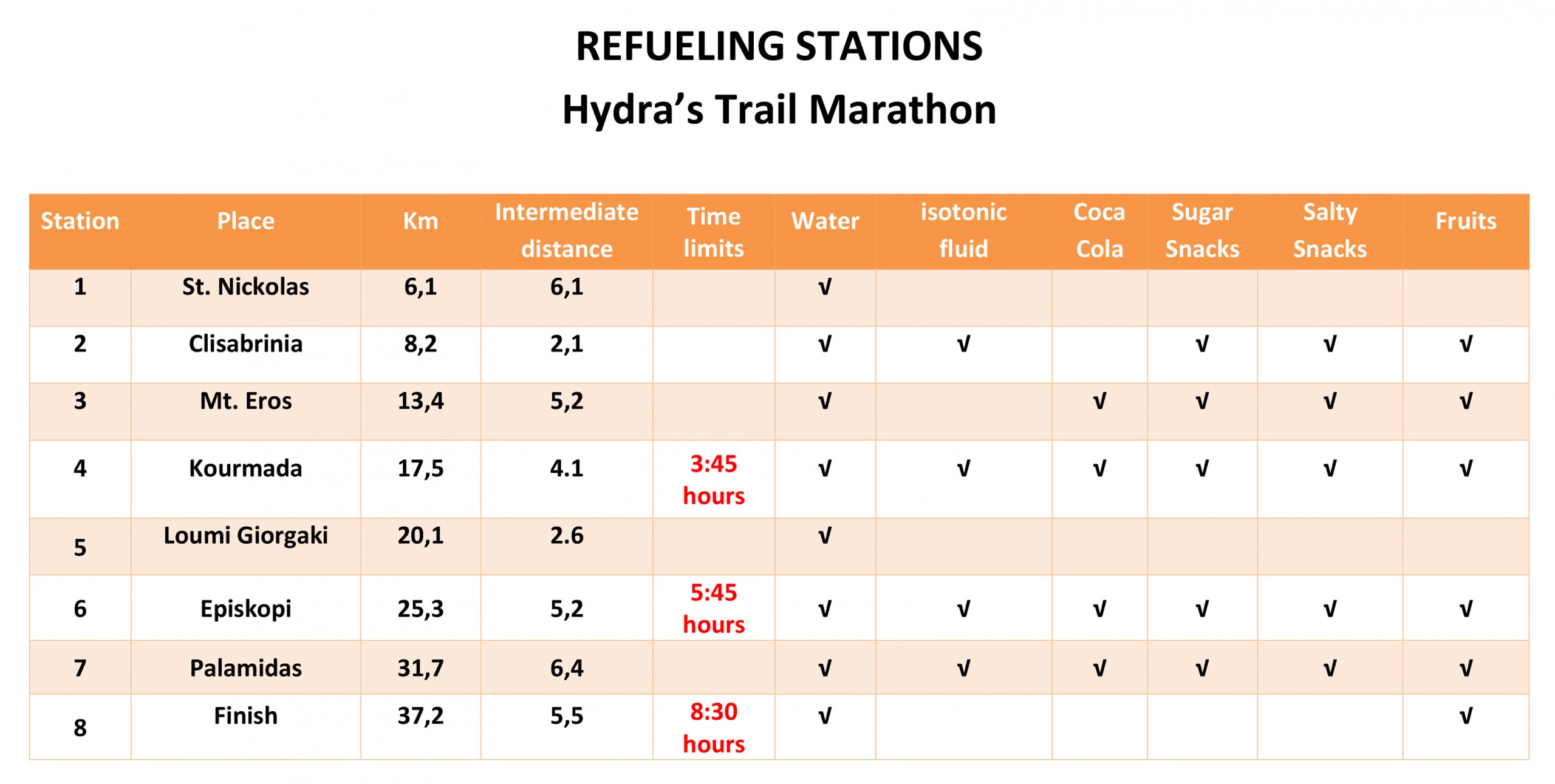
1st section: Distance 6,100 m

Start at the port. We follow the central, cobblestone artery, south, up towards the mountain for 1 km. The 2nd kilometre is an uphill, concrete portion which we exit by turning left on a steep uphill trail known as “red soil”. After 2.9 kilometres the trail takes us downhill to the windmills (km 4.7). A mild downhill leads us to a dirt road, where we bear right, on level ground at first and then uphill. Just before the highest point (5.9 km) we turn right and up and we bear right again at the next dirt road where we reach 1st Refuelling Station (6.1 km).

2nd section: Distance 2,100 m

On our left we can now see a spectecular beach (Limnioniza) on the back side of Hydra and an old threshing floor. Caution! Don’t let the breath-taking view lure you downhill! On the contrary, we go uphill through the pine trees to the highest point (6.8 km) where a steep downhill will take us to the dirt road at kilometre 7.3 which leads easily downhill to the 2nd Refuelling Station (8.2 km)

3rd section: Distance 5,200 m

Because of the distance between the Stations and the elevation gain, this is arguably the hardest portion of the race. The dirt trail is level for the first 3 kilometres and then a steep uphill on old cobblestone begins. Locals refer to this portion as the “soul tormentor” but the breath-taking views might sooth your soul a little. We reach the mountain ridge and enter a short downhill trail through a pine forest. Exiting the forest, we must turn left (CAUTION! THE OLD ROUTE WENT STRAIGHT!). Soon, at km 13.4, we will encounter a volunteer at the point where the two routes (“Rock Race” and “Hydra’s Trail Marathon”) split. 3rd refuelling Station is at 13.7 km. Water is provided here.

4th section: Distance 4,100 m

We walk up a very steep, rocky trail. After 600 m of challenging terrain we reach the summit. Here, at the designated point of the Hellenic Military Geographical Service, at elevation 588 m above sea level and 14.1 km from the start there will be a name-check for all the athletes. The parallel, downhill trail from the summit is equally challenging, rocky and slippery so athletes are advised to be particularly cautious. After about 600 m the challenging part is over. (CAUTION! THE OLD ROUTE WENT LEFT FROM HERE!) We keep continue to the pine tree forest and we pass through Ag. Efpraxias monastery. Then we follow the cobblestone stairs, for the way to the highest point of the town, which there is the 4th Refueling Station, at “Kourmada – Agios Theodoros” (17,5 km).
Here there is a disqualification limit of 3 hours, 45 minutes. Athletes who haven’t reached this point by this time will be disqualified.

5th section: Distance 2,600 m

After the 4th Refuelling Station (“Kourmada – Agios Theodoro), we take an uphill, well-designated path which will be used for the first time. It will lead us to an intersection called Loom Yorgaki, where 5th Refueling Station is at 20.1 kilometres.

6th section: Distance 5,200 m

For the first time we will go downhill, descending the back side of the island, passing a chapel and old, stone threshing floors towards Nisiza beach. Going over rocks, we pass the beach at kilometre 23.5. The uphill trail leads us to the remote settlement of Episkopi, where 6th Refuelling Station is located at kilometre 25.3
Here there is a second disqualification limit of 5 hours, 45 minutes. Athletes who haven’t reached this point by this time will be disqualified.

7th section: Distance 6,400 m

Passing through the settlement, we go uphill through a pine forest to the even more remote settlement of Zogeri. It is the first time that the route passes through this, southwestern part of the island. From Zogeri we go downhill through a beautiful, pristine forest towards Molos beach at kilometre 29 which will make all the athletes “forget” their fatigue. For 100m we run on pebbles and then uphill to the next beach, Palamidas, an old shipyard, and 7th Refuelling Station at kilometre 31.7.

8th section: Distance 5,500 m

This is arguably the most beautiful portion of the route with the sea and small, rocky islets with chapels on our left. One last uphill to the chapel of Agia Irini and back down to follow the dirt road along the coast all the way to the village of Vlyhos, over the arched foot bridge and onto cobblestone again until the picturesque village Kaminia. We pass through its quaint little fishing port, stone houses and Tavernas heading for the port. Approaching the finishing line at the main port of Hydra, we can now hear applause as we enter the horse-shoe shaped harbour. All the residents of the island will be there to cheer on each and every athlete!

By clicking or by scanning at the QR Code, or HERE you can download the route as gpx file

Map Route

YouTube
YouTube
Instagram